Tuesday, January 18, 2011

Upper Middle Fork Eel River: Day One

On May 2nd, 1993 a group of kayakers attempted a first descent on the upper Middle Fork that flows from the Yolla-Bolly wilderness.  This trip resulted in the fatality of early Czech paddling phenomenon, Jaroslav Mach, forcing abandonment of the trip and generating a bad reputation for the river.  There is literally no information regarding this 22-mile stretch of river or of the attempted first descent, merely a tragic legend from Lars Holbek’s NFMF Feather River Description on page 128 of The Best Whitewater in California.  After one of the wettest Northern California springs on record, we decided it was time to revisit the Upper Middle Eel.


History: Round Valley Reservation
The drive to the Middle Eel takes you through the beautiful Round Valley.  Round Valley is culturally and geologically unique.  The original inhabitants of the area were the Yuki tribe who established themselves thousands of years ago.  The Yuki lived in this harmonious setting for millennia until the arrival of white, gold-seeking settlers in 1854.  Conflicts escalated in 1856, and the entire Middle Eel Watershed was designated “Nome Cult Reservation”.  This was probably due to its remote setting and a lack of gold-bearing rocks, but officially to ‘protect’ local tribes.  By 1864 however, the reservation was reduced to 1/5 its original size and became known as the Round Valley Indian Reservation.

 
Round Valley

Because the land was considered to be of little use to the white man, other Native American Tribes were displaced from all around Northern California and forced to relocate here.  This includes the Nomlacki, Wylaki, Lassik, Sinkyone, Pomo (Including Cahto, Kabeyo, Shodakai, Yokayo, Shokawa, Shanel, Kashaya, and Habenapo among others), Wappo, Concow Maidu, Colusa, and Achumawi.  These tribes were relocated here prior to reducing the reservation size.  The Nome Cult Trail was named after 461 Native Americans from these various tribes were forced to march a veritable “trail of tears” guarded by soldiers.  Leaving from Chico on September 4, 1863 they marched across the central valley and over Mendocino Pass, reaching the Eel River Camp (the Black Butte River Confluence) on September 17.  The trip resulted in 32 deaths, a few escapees, and 150 natives who were left behind since they were too sick to continue.  Men, women and children were all forced to make this 100-mile march to the Nome Cult Reservation that finished a day later.  Following these events, the Round Valley Reservation remained relatively unaffected for nearly a century, until water politics forced the re-appearance of government bureaucrats and legislation.

Geology: Yolla-Bolly Mountains:
The Northern Yolla-Bolly Range marks the southern terminus of the Klamath Mountains geologic sub-province.  The higher peaks are volcanic with abundant granitic and basaltic formations.  However, the southern extent of the range through which the M.F. Eel flows contains almost entirely coastal-origin metamorphic and sedimentary rocks.  This river has some of the most unique rocks I have ever seen, from gorge walls lined with red and green chert to sandstone bedrock and enormous calcite boulders.  In fact, the most similar scenery lies along the coast.  Though we expected menacing undercuts, man-eating sieves and gorged-out mandatory rapids, the river turned out to be amazingly clean and runnable.  Passing through a sandstone bedrock gorge on one side, with a grassy hillside on the other is an amazing and beautiful experience.  Nearly all of these grassy slopes are evidence of active earth flows, rather than past logging practices.

Orion Portages Asa Bean

This river is prone to massive high-water events, clearing the channel of any wood hazards at our flow.  This also results in unstable rapids that may be likely to change annually.  During the unprecedented flood of December 22, 1964, the estimated discharge of the Middle Eel at Dos Rios was 270,000 cfs.  This major event caused massive changes throughout the watershed, resulting in what the early paddling community described as a drastic change, namely “all the intermediate and advanced runs on the Eel became easier by about 1 class.”  This resulted from massive deposition of sand and gravel into the river channel, produced from countless landslides due to clear-cutting.  In fact, studies have shown that the average depth of pools in the Eel River watershed has decreased, reducing the abundant cold-water refuge that native Summer Steelhead and Spring Chinook Salmon require.  Not to mention that fish numbers in the Eel River drainage and entire Northern California have dropped as well.

Recon Run:
On May 22, I picked up my friend John Warner and headed south to check out the Middle Eel, flowing 2,000 cfs. @ Dos Rios.  We made the long haul through Laytonville, Covelo, and beyond the Black Butte River confluence to where it leaves the highway.  Much to our dismay, 7 miles up the road we were stopped by a locked gate.  After making the journey however, we were committed to getting on the water.  On our drive back we found a forest service road that descended towards the river, and we followed it to the end.  This put us at a beautiful campsite above the final class III-IV gorge 4.5 miles above the Black Butte.  We were able to descend a delightful grassy hillside all the way to the river (1 mile hike) for an easy-access run with a bike shuttle to boot.  This only whetted our thirst for more adventure in the drainage.  On our way out, John asked the Ranger when the gate would be open, and he informed us it was supposed to be open, but the fire crew had unnecessarily locked it.

Looking upriver near Black Butte confluence

Upper Goods: Day One
Two weeks passed, and we returned with a solid posse of five.  Mike Lee, Orion Meredith, John Warner, Silent Ed and myself made the haul beyond Covelo to get the goods.  The flow was 1,650 and fluctuating daily due to snowmelt so I called the Forest Service office to check on road access and was told that the road to Indian Dick was open.  This would allow us to reach the headwaters of the Middle Eel above its confluence with the North Fork of the Middle Fork (NFMF).  The logistical plan was to break the run up into two sections, hiking out at Pothole Crossing where the road comes close to the river.  This would grant us the ritual paddle without loaded kayaks, as we were anticipating lots of portaging. 

We made the long drive, eventually camping at Hammerhorn Lake.  That first night the Scorpion King visited Orion; the local wildlife was advising us to be on guard.  The crew got an early start, setting shuttle and arriving at Lucky Lake close to 8:30.  This put us on the trail by 9, although we didn’t reach the river and put on until 11.  We were excited for the reasonably early start as the ten-mile stretch averaged 105 feet per mile.  This section required a 3-mile hike down a road and decent trail, although we did note that the game trails are much more heavily travelled.

Miguel Hiking into MF Eel River Drainage flowing right to left
 
Silent Ed at Put-in

            The first mile of paddling to the NFMF was small and creeky; approximately 150 cfs carried us through class III-IV boulder gardens, culminating in a solid class IV canyon above the confluence.  Due to the extremely warm day, Ed decided he was going to skip the drysuit and go skin to wind...this didn't last long and shortly after the NFMF we stopped so he could don his drysuit.


The additional flow at the confluence immediately opens up the riverbed, and after an easy mile of scenic water, we started dropping through continuous class IV boulder gardens.


Then it was time for a little nap


  The canyon was incredibly open, and the river occasionally flowed around the base of enormous rock walls, despite an open grassy hillside along the other bank. 


After several fun miles of water and significant tributaries to add flow we arrived at Asa Bean Crossing.


   I recognized it immediately from a picture in the Wilderness Map and marveled at the stunning stretch of river that dropped through enormous sieves and house-sized boulders.  We portaged through a field of waist-high grass sans-ticks reminiscent of an Austrian landscape.  The ground was incredibly unstable, with cracks, fissures and slumps hidden amongst the grass.  Lucky for us it wasn’t totally moist shoe-robbing goo.  

Silent Ed lets his paddling speak for itself

John Warner cleans the next drop

Ed and John paddled the run-out from the portage that contained several large drops.  Below here more fun rapids continue, as the gradient mellows and the river flows through some gorges of red and green chert.  
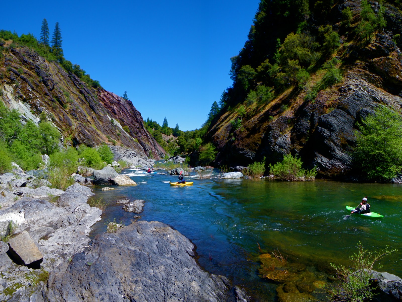


Fun Sandstone Bedrock in this section

Eventually you reach a major pinched out class V drop that Ed and John paddled, until the gradient relaxed for a couple miles.  
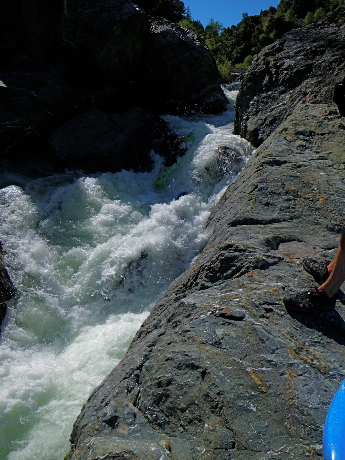
Warner styles the Pinch

By the time we reached Pothole Crossing it had been a long day on the water.  The hike back to the road wasn’t too difficult, as we were able to follow game trails, and happy not to be carrying our kayaks.

Orion reflects on a good day of boatin' 

Sorry I didn't get this out sooner. 

Saturday, January 8, 2011

High Water Three Bears

Howdy everybody,
It's been a busy winter thus far.  Lots of water and surf, but lots of work to be done as well.


When the rains came New Years day, we decided to head back to the Bears, which was flowing a respectable 13,000 cfs. at Hyampom.  Luckily for us, we timed it perfectly and put-on the peaking river, still well within its banks.  Our crew of 6 consisted of three playboats, two creekers, and an inflatable cataraft.  While we were gearing up at put-in, a second crew of two older (and mellower) paddlers arrived and got on the water ahead of us.  I was surprised to see them at such high flows.

After being away from Idaho for so long (~10 yrs), it felt awesome to be in big, pushy water again.  The typical eddy line was 10-20 feet wide complete with whirlpools and crazy boils.  We were expecting to get down the run in 20-30 minutes due to the high flow, but we were dead wrong.

Right away, the first corner has a sick breaking wave on the right.  The eddy service was marginal, but if you wanted it, was possible.  The river continues through fun and large wave trains with occasional play spots created by inundated house-sized boulders.  After Todd Ranch, the play gets better until you arrive at the Bears.


Our attempt to scout the first bear was foiled by the inability to see the river features from the bank, over 200 feet away.  No worries though, it turned out that all of the lines were the same as low water, just bigger.  Remembering the importance of the "buddy system" in big water, I peeled out with Matt Tolley and into some of the biggest water in years.  Next came the rest of the crew, with Grant flipping at the top and running most of the rapid upside down.  In his typical "no-swim" fashion, he made a crux roll, dropped into the biggest hole of the rapid and flipped again.  Everybody caught the eddy on river left as the wave train continued all the way to the lip of Mama Bear.


Mama Bear was easily scouted along the left bank, where you can get a good look at the Mother of all holes.  Our crew was nervously hemming and hawing along the left bank for at least 30 minutes before Ryan da Rafter stepped up to give her a go...Remember what I said about the "buddy system" in big water?  Well we had a breakdown in the buddy system, as I was on the bank holding my video camera and everybody else was watching Ryan's line, trying to psyche themselves up.  What happens when the buddy system breaks down is the true story of the day.  It's not often you have a cat-boat probing the lines.  Mad props goes to Ryan for stepping it up and probing out the line with his cataraft!


Ryan made the entry to Mama bear and approached the crux hole, staying upright with a vicious high-side.  While scrambling to get back on the oars, he dropped into a second hole just downstream and proceeded to get rodeoed directly from his boat and into the maelstrom.  Fortunately Ryan is an incredible swimmer, and deftly made it to the left bank (just downstream was a willow jungle with thousands of cfs flowing through.)  Ryan's cataraft, however didn't make it to the bank, and proceeded downstream through baby bear.
The scramble was on.  I put my camera quickly away and darted to my boat.  Tolley was waiting in the eddy at the top and he peeled out alongside me.  We both managed good lines through the 100 foot wide crux hole, and checked in with Ryan who was O.K. on the bank.  We then peeled back out in the current, dropping into Baby Bear.  I scrambled hard right, barely missing a macking pour-over that Tolley proceeded to drop into and recieve a proper spanking.  The chase was on!  We couldn't even see the cataraft, which was already en route for the Pacific Ocean.  Thinking to myself of possible eddies that the boat might catch before take-out, after a couple of miles we were quickly approaching the take-out when I finally caught sight of the boat, encouraging me to paddle harder.  Finally, less than half-mile from take-out, I saw the boat get surged by a pillow into a tiny whirlpool eddy carved into the cliff wall, complete with whirlpools and large woody debris.  It wasn't that gnarly, but it definitely wasn't a comforting spot.
I forced the boat into a corner of the eddy, and clinging to some alders managed to get myself and my kayak onto the cat.  Tolley and I "cooled out" and waited in the cleft eddy for awhile before deciding our best option was to get downstream to take-out.  Well, I'm no big water catarafter, and surfing the boat across the pillow was enough to get my juices flowing.  But we made it to take-out without incident, and started carrying the cataraft up to the shuttle rig to stay warm.


Meanwhile, the rest of our crew was dealing with getting Ryan back to the river right so he could hike out.  This went smoothly, however in the melee Howie (from the other group) took a swim and proceeded to lose his paddle.  After hanging out at the low-water bridge for over an hour, Matt and I saw a paddler come walking down the road on the other side of the river.  Minutes later, our buddies arrived with a kayak in tow.  Fortunately we were equipped with a breakdown paddle which we ferried over to Howie and watched him nervously as he made the ferry across to take-out.

I consider the mission a great success, we managed to get everyone and all of their gear (minus one paddle) safely to take-out, where we enjoyed some Boont from the can.  "Bahl Hornin'"!  The lesson of the day, however, is the importance of the buddy system in big water.  At 13,000, I give the Bears a class V- rating, merely for the fact that any swim could be long and troublesome...the play was awesome, all of the lines were the same as low-flows and I can't wait to do it again!

Saturday, November 27, 2010

Return to Hardscrabble

Well, I guess its already a new paddling season.  That summer sure was a short one, and the water seemed to just keep on flowing.  After a brief 5" rainstorm this October, we were blessed with the opportunity to get on Hardscrabble Creek.  This run is extremely difficult to hit at a good level, which is basically, high.  You need a lot of water on the Smith to make this run go.  I recommend 15,000-20,000 at a minimum, and if its dropping quick you may already be out of luck.  The best way to gauge it is visually inspecting the take-out and hoping all the rocks are covered.  It it looks bouncy or scratchy, go elsewhere...that being said, we arrived and it seemed a little bony.  But we were jonesing to go creeking, and it had been raining hard so the hope was for rising levels.  During the shuttle drive to put-in, we encountered monsoon-like conditions, which brightened the mood.

  Once on the water, you will be scraping over many sharp rocks in a tiny creek.  Eventually you reach another tributary, and then another, until it suddenly seems like a reasonable flow.  Where the canyon necks in, and a road is visible on the left, get out to scout the first gorge.  By walking down the road on river left you get this view of the steepest part of Hardscrabble Creek.  We were stoked because the flows seemed to be coming up after that downpour on our shuttle drive.


Downstream, another large tributary comes in, and the creek backs off for a little while.  Damon Goodman and Craig Hull enjoying the October creeking.


Eventually you reach a long and steep boulder garden rapid where the canyon opens up.  This is followed by a calm pool and horizon line signaling this drop.  Chris Zawacki boofs on an earlier trip.


Then it backs off again, for a little while.  As the gradient steepens up again, be prepared to portage Judo-Log Roll, one of the sketchiest logs I've ever seen.  This rapid is named after Alex Wolfgram escaped a sketchy situation, where he was splayed over the log with his leg trapped in his boat which was underneath the log.  Be extra careful to scout this one because the log isn't easy to spot...making it extra dangerous.  Here is a shot of the rapid preceding Judo-Log Roll, in the foreground is the entrance.


Damon Goodman looking at Judo-Log Roll


Downstream from here is another heads-up portage where the creek plunges off a falls into a log filled gorge.  This one is hard to spot ahead of time, but comes on a slight right hand bend where a small side channel takes off to the right.  The portage route we've always used requires side-hilling through huckleberries and poison oak on the right.  But the last time we did it, it looked like a river level route exists, which would be wise.  After lowering our boats down a steep hill to this rock precipice, we engaged in the classic bouncing seal-launch.  Here is Damon preparing to drop in.


Craig Hull executes the same said maneuver.


Damon sticks the excellent boof just downstream.


Craig Hull follows suit.


From here, there are still some big boulder-garden rapids with log hazards.  We portaged Billee's Goat, as a log that always backed up a hole seems to have gotten worse.  Towards the end it starts mellowing out.  We were lucky, the last-minute downpour on the shuttle drive gave us just the water we needed, and flows were the low side of good.  We hit the peak of the flow: 19,000 cfs, and it was just enough water.  This creek is a boat-abuser, especially at lower flows.

Thursday, August 12, 2010

Swift Creek Gorge--Photo Update

This is a two-part story.  During the last two years (2008-2009) I was working in Weaverville during the summertime.  Fortunately, my co-worker Damon Goodman, is/was an extremely talented kayaker and willing to take on Swift Creek gorge.  We first paddled it in the summer of 08 (smokiest summer ever), but only once.  It was an after-work run, leaving Weaver-vegas at 5:30, and we portaged the final falls.


  In 09 however, we made 4-5 more trips up to Swift, to get the goods!  During 09 though, every time we paddled Swift was during a thunderstorm, so no good pictures were taken.


 Lessons learned in 09 and 2010 should be passed on, as well as some good lighting.  Not to mention that taking your time, as opposed to doing an after-work run, is much more enjoyable.


John Warner Nails the Entrance Fall

The entrance falls (and the entire gorge) is extremely sensitive to flow: with higher water the hole is stomping, and pushes directly into a cave behind the falls.  Scout the entrance carefully.


Matt Tolley, Tappin' in!

Just downstream of the entrance fall, is a riverwide portage log, that slightly shifted during the high water winter.  Still a portage though.  The very next drop is the perfect pour.


John Warner with the perfect line.

This drop is directly above another elbow-crunching "portage" that we don't have the balls to run.  It's a crack/slide into a meltdown with a consequential rock-pile just downstream.  The portage route is skinny to get into, always check this on a pre-run scout for safety (unless you plan on running Elbow Cruncher).

Downstream is a triple-boof around a corner.  This rapid had a new piece of wood in 2010, that we were able to boof directly over, but should be scouted for 2011.


Matt Tolley sticks his boof in Swift Creek Gorge

The final falls needs a good name...Fire Left, Boof Left, Right moving Left, Get Left, Southpaw Falls, Left or Crunch Falls


John Warner took this shot.

Left or Crunch has handed out several funky-chunky lines, resulting in pain.  I recommend scouting this one carefully, as it has a hidden "shelf" rock halfway down, not to mention the enormous shelf that protrudes from the right bank.  Essentially, in a boat-width wide entry, you want all your Mo to be carrying left, or else.  

The rest of the run becomes extremely manky at lower flows, but also contains some fun boat-scout rock dodging.  Be careful of logs.  Pretty much everyone to paddle Swift Creek Gorge considers it a classic, and one of the best creeks in the area.  Sine it flows pretty late (Trinity above Coffee Creek ~250-125 cfs) it is an easy one to hit, as well as a short one mile hike on the well-marked Swift Creek Trailhead.  Scout your take-out as you begin the hike upstream from the trailhead.