Friday, March 16, 2012

Six Rivers Source to Sea Expedition--Van Duzen River: Goat Rock


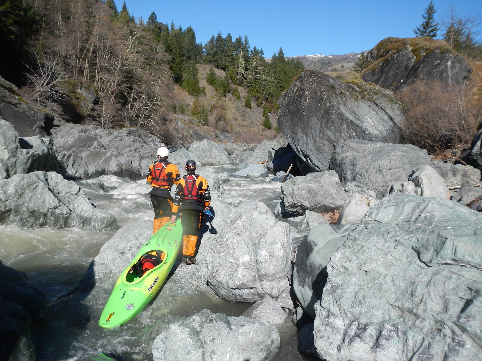
Returning to the very same spot we took off the Van Duzen two weeks before was an exciting feeling.  We were stoked to have accomplished the Bloody Run and equally stoked to be getting on the Goat Rock section at a great level on a beautiful sunny day.  Flows were right about 1200 cfs on the gauge at Bridgeville as we drove through the unadulterated redwood groves that dominate the Highway 36.  Since we were along the Highway 36, perhaps the most hitchhiker-friendly road I know of, we shared a ride knowing shuttle would be no concern.  Along the way we spoke of how the long-range weather forecast was changing and beginning to show signs of storm activity.  This was equally exciting to us as our plight to paddle all Six Rivers of the National Forest seemed in jeopardy due to a lack of sufficient snowpack and water in general.  We put on at the confluence of Little Larabee Creek, where an easy trail leads to the river.  Not before we took a look at Goat Rock Falls from high above though.  Here is the overlook view of the entrance crux and the Pinch below.  


 For kayakers, even locals (with the exception of one) Goat Rock isn’t even on the map.  Mostly paddlers come to the Duzen for the classic Grizzly creek section downstream and at high water will occasionally drive up to Goat Rock Falls to stare in awe at the amazing spectacle.  At 20,000 cfs it truly is amazing to look at and there is a perfect trail leading down to an overlooking precipice from the road.  I have paddled on the section once before but circumstantially, when we arrived at the crux we hiked out up the right bank in the dusk.  That was over 10 years ago and after recent forays into the drainage and seeing the drop at reasonable levels I was really excited to get on the run again.  Goat Rock also comes highly and unconditionally recommended by the fabled local boater Silent Ed, who paddles it solo regularly.  Here Paul scouts the crux from above at river level.

Photo: Wes Shrecongost


Paddling downstream the river has a great pace, much better than the flat-water paddle-out from the Bloody Run.  We passed through the zany town of Bridgeville, which has a storied history as of late.  Bridgeville became widely publicized as the first town to ever be sold on E-Bay for a cost of $700,000 in 2002, only to be resold again in 2006 for $1.25 to a self-made 25-year-old millionaire.  The sale included 3 cows, 8 houses and a post office, sounds like a good deal to me.  But the story doesn’t end there; three months after purchasing Bridgeville the new owner tragically committed suicide with a gunshot wound to the chest.  I told the boys about this as we floated past town and directly underneath the highway bridge we came across the first rapid.  The Bridgeville Boof left a good taste in our mouth and we all wish shots were taken (no pun intended).

Downstream from town the Duzen lets up briefly with an extended warm-up before getting down to business Van Duzen style…a blind horizon line with large boulders blocking the view.  We scrambled briefly as I scratched for an eddy at the lip, then peeled out through a narrow slot drop into a boiling hydraulic and around the backside of a monstrous boulder.  I was all good below the drop but unable to communicate that to the crew above and had to wait for a minute before they all came charging through.  We continued downstream through more excellent class III-IV boogie before reaching the Headwall of Goat Rock proper.  


Photo: Paul Gamache

Looking downstream at the runout of the crux and the entrance to the pinch

Photo: Paul Gamache


The entrance drop into Goat Rock is the most critical move and has the biggest hydraulics due to the steep constriction along the massive river left wall.  With our healthy level the hydraulic at the bottom proved to be a stopper, but not a tractor beaming SOB.  This was good because there is only a very short break before the next drop.  In fact, the entire Goat Rock section is really only a ½ mile long rapid with 4 critical moves, and it can be easily broken up by catching large eddies.  Because of this Goat Rock is not recommended above levels of 1,500 cfs at Bridgeville.  This is also not a great run for beginning creekers at the higher end of the runnable flow range.  I would recommend starting between 800-1,000 cfs to familiarize yourself with all the moves and the hazards before pushing the level up.  Portaging the main drop is difficult and only small eddies exist above 1,000 cfs.  Goat Rock is a solid class V considering the many inconspicuous consequences.  

The second crux just downstream is the Pinch, where the river is funneled through a backed up ledge hole that feeds into a slot.  The drop is straightforward but I’d hate to be getting surfed in that hole so keep your nose up!  Looking upstream from Goldenbeard at the pinch.


Photo: Paul Gamache
 
The outflow from the pinch pushes towards river left where a hideous sieved out rock pile lurks.  The Goldenbeard Boof is on the right and where you want to be, really.  Looking downstream across the lip of the boof at the hideous rock pile in the background.

Photo: Paul Gamache
The third major move is Goldenbeard, a money boof drop where the line is hard right, almost against the bank.  As with all drops on the Van Duzen you should inspect them carefully and regularly depending on the flow levels…many unknown hazards exist and the turbid brown water can hide rocks mere inches beneath the surface.  Boof the crap out of this one!  Looking back upstream at Goat Rock and the Goldenbeard boof.

Photo: Paul Gamache
Birds eye view of Goldenbeard from the overlook.


The Runout from Goldenbeard
Photo: Paul Gamache
Goldenbeard feeds directly into a class III run out before the final drop of the section, The Deathtrap boof.  An appealing and straightforward boof line exists down the right channel, however a sneaky and extremely dangerous crack in the rock is just to the right of the line.  Inspect it carefully, but enjoy another high quality boof the Van Duzen has to offer.  

Photo: Wes Shrecongost

If you go too far right for the boof a dangerous siphon could potentially do bad things.  Boof 4 safety like Wes Shrek is doing below in the only kayaking picture we have from the day.  

Photo: Paul Gamache

It was a beautiful day and we ran this boof a couple of times for good measure.  

Photo: Wes Shrecongost

Will, Paul and Me downstream of the Siphon, fired up on the quality boofs we'd paddled.

Photo: Wes Shrecongost

Downstream the river mellows into a class III paddle out most of the way to Golden Gate Bridge, the take-out.   Be courteous of the friendly locals here as it is their neighborhood.  As mentioned, we hitchhiked our shuttle because Highway 36 is where its at!  Friendly locals, good weather, amazing scenery and great boofs less than an hour from home…how come this was my 1st time?
Wednesday, March 14, 2012

Six Rivers Expedition-Eel River Dos Rios to Fortuna

Will Parham, Wes Schrecongost, Victoria Anweiler, Dan Menten and Paul Gamache
Photo: Toni Morzenti
This was an epic paddling trip thought up on a whim by the six rivers team.  Originally the plan was a 2-day trip from Alderpoint to Fortuna, which we thought would be a bit low, and a long two-day.  Somehow the go-getting attitude of the crew took over and we decided hell, while we’re add it why don’t we just add another day and 47 miles of whitewater and do the Dos Rios to Alderpoint section as well.  It certainly simplified our shuttle logistics and with enough water we thought it would be doable.  Fortuitously, a much-needed storm delivered a modest amount of precipitation that was followed by several days of beautiful forecasted sunshine and the plan seemed to be manifesting.  Joined by two friends, Arcata whitewater enthusiast Victoria Anweiler and Idaho/Humboldt wave shredder Will Parham we were also graced by Wes Schrek and the presence of the Six River’s Expeditions #1 sponsor Toni Morzenti who found time to drop off the adventuresome crew at Dos Rios. 


 Meeting at the crack of dawn 5:30 we did the normal stumble around loading gear in the dark routine before loading into Wes’ truck for the 2:30 hour drive through Eureka, down to Fortuna then along the Eel River all the way to Garberville, and finally Laytonville before we turned onto highway 162 towards Covelo and shortly thereafter we arrived to our put-in at Dos Rios.  While we gathered our gear a friendly local came down to chit-chat with his more than friendly dog.  The old-timer told us that it had been an amazingly dry year and that up until a couple of days ago “the water had been running crystal clear” he then continued “you shoulda been here last year there was tons of water “ I looked over to see the dog humping on Toni’s leg who disapproved.  The old man continued “them rafters who come here in May are gonna be pushing their boats across the riffles”.  I looked down and noticed the dog sitting inside of my kayak, that I happened to be trying to pack.  Eventually the old man and the dog left us to our devices.  Paul and I were both paddling old Wave Sport Lazer’s, which we quickly realized were not good boats for overnight trips as they were extremely difficult to pack.  After some struggling to fit our ‘essentials’ we still had gear strewn about.  Luckily Will and Victoria were rocking Sea Kayaks and we found some extra space in the cargo hatches for the overflowing food and gear.  We took a group pic and said goodbye to our #1 sponsor before heading towards the river.


We elected to put-in downstream of the confluence, which is not a good river access.  Well it’s alright for kayaks but rafts need to use a river access upstream of the middle fork confluence where a much better access exists.  We walked our way along the railroad tracks and then down the hillside to about 4,000 cfs on the Eel River.  The very first rapid had an amazing wave and the pace of the river continued swiftly as we found ourselves in the classic whitewater section with a healthy flow.  Will and Victoria both represented by paddling sea kayaks, which took a little bit of adjusting since they aren’t quite as maneuverable in the rapids.  Our estimated put-on time was 10 o clock, and we were happy to find beautiful sunny skies and a healthy current to carry us along.  We had no idea how long the 100 mile, 3-day trip would take us and were fearful of falling behind schedule so we approached the river with a touch of haste.  


We definitely took time to marvel at the wondrous railroad ruins that lay spread throughout the canyon.  The recently controversial and now-defunct Northwestern Pacific Railroad line runs through the Eel River Canyon.  It is mind boggling to stare at the many failures along these tracks where active earth flows have caused slumping, landslides have blocked tunnels and taken out the tracks, and culverts have been washed from their places.  It is equally mind boggling to consider some of the locations of train wreckage such as boxcars and flatcars that have managed to work their way far from the railroad tracks where they came.  The massive power that the river has to transport enormous chunks of steel such as these, and pile boulders upon them ten feet high, is a testament to the power of water and Mother Nature.  The railroad line was built during the early 1900’s and stopped running following the high water year of 1997 when most of the wreckage occurred.  Consider it recent history.  Here Victoria passes an old Boiler Car.


The railroad line has been described as looking like a "roller coaster in places.

Photo: Wes Schrecongost
Talk of trying to re-open this railroad line can be thought of as nothing more than a pipe-dream, however somehow the pipe-dream has stayed alive.  Considering the amount of wreckage and sustained damage to the tracks from 15 years of neglect coupled with the lack of Old-Growth redwood forests to clearcut (they've all been cut or protected) its time to let it go.  Rant: As much intrinsic historic value as these train tracks have (little to none) I think of them as nothing more than litter.  Only in America can wealthy corporations build a rail-line to exploit natural resources and then abandon them completely once the resources have been exploited, with no repercussions or responsibility like picking up their garbage.  

Photo: Wes Schrecongost

 We hastily continued downstream although the pace of the river had slackened somewhat.  On the right bank we encountered several families of wild boars with litters of baby boars running amok upon the hillsides.  Eventually Spyrock came into view and we decided to take a short break to admire its beauty.


 Unique Eel River Metamorphics


After our break, the best section of the run ensued.  From Spyrock down past the North Fork of the Eel confluence 10 miles further, the pace picks up with more gradient, boulders and of course, excellent play spots.


Just another unnamed wave-hole

  
 The crew was thoroughly enjoying themselves as the miles were coming easily and the weather and scenery was beautiful.  We eventually took another short break at the North Fork Confluence before continuing downstream.  At these higher flows the current really does carry you quickly and before we knew it we were arriving at the Island Mountain Falls section.  We routed our way into the rapid which has two parts, it starts with a tricky ledge drop, then you find a good slot where the river enters a boulder fence.  We all had good lines and were soon passing beneath the train bridge before the notorious railroad tunnel. 


The river then makes a gigantic oxbow bend before returning to the train tracks.  This section is very beautiful and has some excellent camping opportunities; a couple of fun rapids lie in the oxbow as well.  After 5 miles you return to the tracks at the opposite end of the train tunnel, which is your signal that Kekawaka falls is ahead.  This is another standout rapid that stuck in my memory and wasn’t quite as big as my previous trip but it still packed a whallop! 


We continued to charge downstream through more fun water and I suddenly realized how much excellent whitewater this section truly has.  Although it gradually lets up towards the end of the run there are still fun rapids with character and good playspots to keep you on your toes.  At this point we had covered almost 40 miles and decided we’d made enough progress to camp for the night.  A nice beach then presented itself to us with abundant dry wood, a small creek, and a guarantee of afternoon and morning light and we decided to call it a day. 

Photo: Wes Schrecongost

High fives for all, we’d kicked some serious ass.  Although we were concerned that the dropping water levels following the storm might make for some difficult flatwater ahead, we had already taken a big chunk out of our goal and felt good. 


We awoke the following morning to a hanging fog and all stayed in our bags for awhile since we were tired from the previous day’s early start.  The water level had definitely dropped overnight causing gravel bars to appear where water had flowed the previous night.  After stoking our fire the sun finally broke through the clouds bringing its motivating warmth.  Soon thereafter we were packed up and launching for another long day on the water. 


After a short while on the water we passed the second major train bridge indicating that we were nearing Alderpoint and once again I would be paddling on new water. 


The section between Alderpoint and Fort Seward proved to be mostly flat, however it is here that the Eel River makes a major transition.  Up to this point oak woodlands and enormous grassy hillsides have primarily dominated the scenery. Downstream of Alderpoint the Eel River works its way into a lusher coastal climate.  The forests get thicker as a result.  The river also cuts through a beautiful rock gorge in here with an amazing looking campsite that we all felt would have been ideal….for next time! 


The view from sik Camp


As mentioned there were really no rapids between A.P. and Fort Seward but the amazing quality of the river kept the crew’s spirits high and before we knew it we’d passed beneath another bridge and we were stoked to be covering ground.  Due to the dropping water levels we hoped to keep our progress and make our final day on the water an easy one, rather than a death-slog.  Downstream from Fort Seward the river enters another beautiful roadless section. 


After passing the confluence of Dobbyn Creek on river right, which looked inviting, we arrived at the confluence of a beautiful tributary on the right and decided to take a lunchbreak.  We completed the lunchbreak with an excellent side-hike up the creek that comes in here. 


Photo: Wes Schrecongost
Somewhere after lunch the flatwater started getting a little intense for the boys in the Lazer’s.  We couldn’t really feel our legs due to the awkward old school outfitting forcing our circulation to a halt.  Eventually we saw what looked like a mirage but was really another person..and a dog.  It was the first human encounter we’d had since put-in.  After eddying out the friendly local, who was eager to chitchat with us, had to restrain his gigantic German Shephard puppy as we tried to have a conversation.  The dog barked on and tugged at the leash as I asked him our location.  “You’re in Eel Rock” he said, and then the dog barked and tugged at the leash some more.  This was getting old and I’m sure his arm was tiring so continued downstream through more amazing roadless scenery. 


Eventually we paddled through an amazing canyon stretch that lies in here. 


Good crews come together


The canyon downstream of Eel Rock was high quality and we were lovin' it


The fading daylight and beautiful scenery urged us to camp here as we were quickly approaching highway 101 and the South Fork Eel Confluence downstream.  We had a hard time picking our ultimate campsite but eventually scored a nice gravelly bar with wood, creek, and promise of morning light.  Another beautiful day on the water was celebrated around the caveman T.V. like a happy Neanderthal family.


Foggy morning at camp 2 in the dampness of Humboldt County's coastal climate

Photo: Wes Schrecongost
We woke on day 3 to a dewey fog reminding us we were close to the coastal dampness.  The sun rose and quickly burned through the clouds again and before long we were packed up and on the water for the final leg of our journey.  The water level had dropped again, but only slightly and we were excited to see more Redwood scenery as we were looking forward to passing some old-growth groves downstream from Highway 101 and the South Fork Eel confluence.  In the midst of our morning haze we reached the small town of McCann and encountered an especially dangerous low water bridge situated at an angle to the current that required ducking.  Too much more water would make this a potential deathtrap.  This was our sign of civilization and we quickly arrived to the confluence of the South Fork downstream.  There was lots of flatwater paddling to be had and we each had our own way of dealing with it:  Victoria would sing to her favorite poppy 90’s tunes, I whistled to the chirping birds, Wes was taking pictures, Paul was paddling as hard as he could about ½ mile ahead of us or more, and Will was trying to keep up with the crew about ½ mile behind.  Anyways, we had done it!  We made it to the South Fork confluence where the towering redwoods of Founders Grove and the Avenue of the Giants greeted us like a welcoming party. 


The pace of the Eel continued along with a very steady current like it had all along since Alderpoint.  Despite the lack of rapids we were finding it surprisingly easy to cover miles and contribute it mainly to the flow.  Downstream from the S.F. confluence the Eel flows around the base of several gigantic sandstone rock outcrops along the right bank called High Rock. 


The scenery is incredible in here and we were all enjoying ourselves thoroughly.  Will inspects the spectacle.    


We still had miles to cover however, and put our heads down, skipping lunch in hopes of feasting at the Eel River Brewing Company where we had arranged to have our shuttle vehicle dropped off.  But it was too soon to start thinking about burgers and Beer, because we hadn’t even reached Rio Dell yet.  Several miles downstream we passed through Holmes with the confluence of Larabee Creek on river right, which was flowing nicely.  Just downstream is another low-water bridge that was barely submerged at our level and could pose a serious hazard at slightly lower water levels.  Its good to know this is here and be heads up about it and you’ll be safe. Eventually the grassy Bear River ridge came into view and then the next thing you know…we were passing the Scotia Mill and nearing the Scotia Bluffs.


The River flows around the base of the Scotia Bluffs which were known as one of the most treacherous spots along the old Northwestern Pacific Railroad line.  Apparently the track was so unstable through here that trains passing by had to slow down to 10-mph. maximum so as not to cause damage to the wooden track supports. 

Photo: Wes Schrecongost
The Eel continues downstream with its characteristic swift current towards the Van Duzen confluence, at this point the channel is so big that the river flows in a very straight line, reflecting its high water personality.  Downstream from Rio Dell the canyon walls quickly back off as you enter the grassy plains of the Eel River Delta.  Before we knew it we passed the Van Duzen confluence and could see the houses of Fortuna in the distance.  It is Duck-Hunting season however, and we were greeted back to civilization with the repetitive blast of shotgun-fire coming from the left bank.  Unable to see the gunman we were all feeling wary and happy when we arrived to the Fortuna River Lodge.  Celebration was had at the Brewery, and more plans were hatched for the oncoming storms.   The Eel River had an amazing character that exceeded all our expectations and surprised us with its undeniable quality.  I recommend this splendid river that has many roadless miles of scenic water to be enjoyed.
Caution: the Eel River is notorious for strong afternoon winds that blow upstream and hamper downstream progress.  For this reason I recommend slightly higher water levels or early starts to increase the pleasure of your experience.


Monday, March 5, 2012

Van Duzen River--The Bloody Run Day Two


Check it out, Explore Six Rivers Source to Sea
If you haven't read it here is the Day one description
 Here is Paul's Helmet Cam Footage of the Bloody Run

Photo: Wes Shrecongost

We slowly woke up on the second day to a cold heavy frost.  After staying in our sleeping bags to retain warmth the sunlight peeked up over the hillside and its strong rays coaxed us from our cozy confines to  get ourselves fed.  Knowing it would be another full day on the water we optimistically hoped that at some point the river character would change and open up into more runnable rapids.

Photo: Wes Shrecongost
The river level had dropped only slightly overnight and after we packed our boats and pumped drinking water we were ready to go by nine o clock. 


Downstream from camp we were treated to an easy section of water with beautiful Van Duzen scenery before more congested boulder gardens reappeared and it was back to the portaging routine.

Photo: Wes Shrecongost

The river seemed to be changing for the better, as we found good lines through more rapids than the previous day.  Our runnable rapid to portage ratio began to balance out closer to 50:50 and we enjoyed some of the best rapids of the run.


This still meant dealing with many large boulder gardens that made for exhaustive portaging, not to mention we were all shagged out from the previous day’s efforts.  Get back up to the hillside...yeehaaaawww!


Now go through that poison oak bush...you know you like it!

Photo: Paul Gamache

Finally we reached an extended calm period of water and began to get our hopes up that we had passed the meat of the run. 

Photo: Wes Shrecongost
We now refer to this as the Glimmer of Hope, because shortly downstream the river slid into yet another boulder gauntlet.  Checking our GPS we realized how many more miles lay ahead and started to push harder in hopes of keeping our trip to a 2-day.  

Photo: Paul Gamache
The canyon began to open up with beautiful scenery characterized by enormous chunks of rock.  At this point we also were starting to Bonk. 

Photo: Paul Gamache
Hmmmm...big seal launch into murky brown water of unknown depth or climb around on some giant boulders with a heavy loaded kayak for the hundredth time?

Photo: Paul Gamache
Fortunately for me and Wes, the murky brown water was deep and unobstructed.


Just downstream another fun rapid pinched before pushing into an undercut that couldn't be seen from above.  Wes probes it out.


After a couple more miles of better rapids, the gradient was gradually dropping and we started covering miles without making a portage.  There were some interesting rapids thrown into the mix too.


Wes attempting to spot his line through another boulder jumble

Photo: Paul Gamache
Finally, we passed the namesake drainage, Bloody Run.  This creek comes in from river left and marked the end of the high gradient sections.  It also appears to have remarkably high water quality considering the brown nature of many other smaller side-streams.

Photo: Paul Gamache
One more tricky portage remained downstream before the Van Duzen flattens out for the remaining miles to Bridgeville.

Photo: Paul Gamache


  We passed one massive landslide in here that looked like the entire hillside was basically flowing into the river and it turned out being the final portage of our trip!  We relaxed and paddled the flatwater through beautiful scenery the rest of the way.

Photo: Paul Gamache
Eventually we arrived at the confluence with Little Larabee Creek and Highway 36.  After some celebratory high-fives, Wes made his way up to the road where the very first vehicle driving by picked him up. 

The Bloody Run is an adventure that I hope to repeat someday.  I feel like our mission opened up a run that may become a “cult classic” along with the Grand Canyon of the Mad River, just over the hills.  Several times we found ourselves portaging on the wrong side or around sections we could have committed to had we known there were lines.  With slightly higher water levels many possible routes would open up although many of our portaging options would be limited too since they were at river-level.  I know the write-up description makes it sound like all we did was portage, however looking back at Paul’s helmet cam footage we were also able to run many quality rapids as well.  Best of all, by starting out our Six Rivers Source to Sea Mission with a banging first descent, we gathered the momentum and confidence we needed to keep the ball rolling!


Major points from the trip:
If we had more time we could’ve run more rapids

The Little Van Duzen is a better put-in than Highway 36 to avoid a massive portage near Dinsmore and include another great section of river.

Information about the previous trip got twisted by each successive storyteller, to the point where it was virtually useless.

Exhausting nature of portaging/scouting- The never-ending onslaught of mind-bending boulder gardens takes a toll on your mental awareness and ability to maintain focus.  

Miles were extremely hard for us to cover.  Every time it seemed that we were going into a more runnable stretch of river we found a difficult portage or scout instead.  At one point we were making 1/2 mile an hour.

Difficult decision-making: to portage over this boulder or around that one, to portage up to a grassy hillside or stay at river level.  The river disappears into a boulder garden where 4 of the 5 slots are sieved-out and it becomes difficult communicating lines back to the crew through this complex of rapids.

Importance of bringing overnight gear: although it made our portages much more difficult and extra effort, the gear became worth its weight in gold once it became clear that we wouldn’t be making it out in a single-day. 


Importance of having a map, or GPS to locate yourself and realize how much farther you have to go.

Importance of picking a good campsite, one with flat spots and wood to burn, at the right time of day before it gets too dark to set-up camp.

Sometimes you just have to put your head down and start charging through the poison oak, otherwise it would be impossible to accomplish this river.  However I am happy to report that three weeks later I have no signs of the P.O.!  


The importance of a good crew cannot be stressed enough, we all proceeded safely and patiently which contributed to our safe return.


Going on adventures, even those which require lots of portaging, are still always worthwhile for the sense of accomplishment and change of perception they can provide.