Wednesday, May 19, 2010

Stuart Fork Trinity River: Wilderness Run

After backpacking to Emerald and Sapphire lakes last summer, I decided my return to kayak the Stuart Fork Trinity was imperative.  This is a beautiful river, whose headwaters share the highest peaks of the Trinity Alps with Canyon Creek, the North Fork Trinity, and South Fork Salmon River.  Because it emerges from these glacially-carved granitic mountains, the channel is primarily continuous boulder gardens with round granite boulders.  The gradient is quite steep, averaging 180 fpm, though the first two miles drop 400 feet.  Towards the end you work your way into bedrock drops with some punch, making the most of the gradient.  This also makes for many even, ledge holes to get worked in and also provides some interesting undercuts.


The Stuart Fork area is rich with mining history, during the hike-in you follow the path of a canal used to divert water for hydraulic mining operations.  It's pretty safe to assume that everything has been mined in one way or a nother.  Though this area is wilderness, its crazy to think that 160 years ago it was the most happening place in Northern California.  Looking down at Emerald.


We decided to hike to Deer Creek, approximately 7 miles up from the trailhead.  I roped my buddy Chris Zawacki into making the trek, and we got an early start, hitting the trail by 7:00 A.M.  The hike took us approximately 4 hours, but including our stops, lunchbreak, and brief losing of the trail (not maintained in winter), we probably didn't hit the water until noonish.  We did manage to hike through snow along several sections of the trail, not so rare in May.  Here's a sweet bedrock rapid next to the trail on our way up.


The first two miles are steep and continuous.  It is also incredibly scenic, with mountain views all along.  It really makes you appreciate kayaking, as the views from the river blow away the views from the trail.  Though we could have used more water (1,200 on Trinity @ Coffee Cr.) we had a good flow.  Eddy's weren't numerous but there were great drops where the river squeezed against bedrock and the scenery was amazing.


More of Chris Zawacki on the Stuart's Fork.


One major memorable rapid was at the Alpine Creek confluence, where a boulder garden with 4 or 5 consecutive moves as well as shady off line consequences awaits.  We were tired and took a quick break here.

Downstream you arrive at the Deep Creek Confluence, the falls on Deep Creek has been run, though we decided not to go for it as the creek was quite low.  The falls drops right under the trail.


This marks the end of the boulder gardens and the beginning of more bedrock rapids.


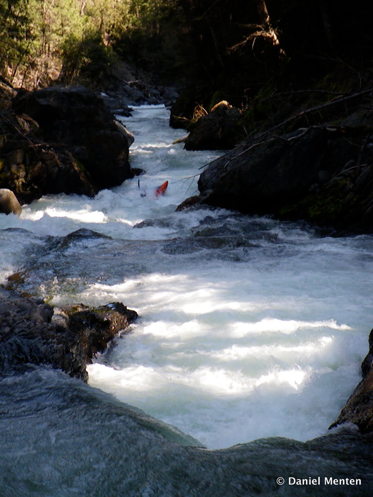
Zawacki styles yet another Stuart Fork Rapid


We decided to portage this drop due to interesting caves along the right side, though it is runnable.


Here is the view looking down another two-part rapid in the bedrock section.


Chris tackles the rowdy hole in part two


Towards the end, we also portaged the rapid at Cherry Flat, happy just to be back near the take-out.
In retrospect, there were endless rapids, and including the 7 mile hike it made for a very long and tiring day.  I consider this run to be a north coast classic, though as much for the scenery and adventure as for the rapids.  Because you hike along the river, you can go as far as you wish, though Deep Creek is a good halfway point.  Get an early start if you plan on hiking to Deer Creek.

The Stuart Fork is 20 minutes north from Weaverville on Highway 3, alongside Trinity Lake.  Turn left after the bridge and drive approximately 5 miles to the trailhead.

Saturday, May 8, 2010

Lower Goose Creek

So, we actually paddled this run back in February, though we did have a great day on the water.  This was probably my fourth trip down Lower Goose Creek, over about a 10 year span.  On my first trip we were able to drive 2 miles down the road to a washed out stream-crossing, and on each successive trip the creek access has doubled, and now tripled in hiking distance to the creek (due to decomissioning of the put-in road).  This year, we had to hike the full 3 miles (downhill, on a road) from the turn-off at Saddle Road.  Despite this less-than perfect access, I still fully recommend Lower Goose, as it is a beautiful creek with great rapids.  Speed-blur: Melissa DeMarie corkscrewing the Honker.


Upon arrival at the creek back in 2001, water was ripping through willows on both banks looking very high, though this turned out to be a great level (12,000 cfs @ Jed Smith).  This year, the level was slightly lower (10,000) though still a great flow.  After a couple miles of steady class III, with fun playspots, you arrive at the first sweet drop, the Gander (Class IV).  This is scouted easily on the right bank, and is basically two consecutive hole-punches over ledge drops.  Miguel charging.


Class III water continues to the next horizon line at the Honker, which is somewhat obscured by large boulders.  This is the largest rapid of the run (Class V), and continues for a couple hundred yards. The easiest portage is probably down the left, which requires eddying out early.  This year I found a great scout angle on the right where you can get an excellent view of the top drop, a boof into a sticky hole, right next to a large undercut.  This would not be a fun place to get worked, though I haven't seen anybody get stuck here.  Miguel sticks his line.


The rapid continues through a boulder garden, before passing an eddy and plunging over the final bouldery exit we ran on the right.  Martin Belden and Miguel showing how its done.


Below here the creek lets up for a couple of miles, with a class III-IV character.  The canyon is incredibly beautiful, and because this run flows north-south it can often be sunny in the middle of winter.
The Ugly Duckling is the final rapid (Class IV), with another slightly obscured horizon line.  The current charges at a big boulder before continuing to drop over a sliding runout.  John Warner sticks the line.


A couple more corners brings you to the confluence with the South Smith, and a wicked fun eddyfence where the currents converge.  At higher flows, there are several fun play-waves and holes between here and Steven's Bridge, the take-out 1 mile downstream on the right.  There is a good eddy and trail on the downstream right side of the bridge.

To reach Steven's Bridge, drive 10 miles up South Fork Road from HWY 199.  There is good parking across the bridge (river right).  To get to the "trailhead", drive upstream, turning right at the Gasquet-Orleans road in one mile.  Two miles up this hill you will reach an obvious "saddle" on the right side, with several random roads and lots of shotgun shells in the large flat area.  The road you want to put-in is in the back, on the left, and proceeds downhill 3 miles to the creek.     Good flows are 6,000 to 14,000 at Jed, though I prefer 8,000+.  Have fun.